Support

Siring Kota Banjarmasin

About

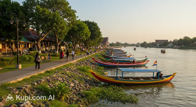
Imagine a vibrant and modern embankment where the rhythm of the city meets the serenity of the water. Siring Park is an iconic public space in the heart of Banjarmasin, located along the scenic Martapura River. This cozy recreation area in South Kalimantan province, Indonesia, has become a favorite spot for strolls among both locals and travelers.

Siring Park Banjarmasin
Siring Park Banjarmasin. Иллюстрация. Источник: Kupi.com AI

The park is a well-designed area featuring shaded alleys, observation decks, and green spaces. Its architectural highlight is the tall observation tower, which offers breathtaking views of the city quarters and the endless movement of boats on the river.

This place is rightfully considered the city's cultural hub. It harmoniously combines opportunities for active recreation, quiet nature contemplation, and local architecture. Taman Siring is the perfect spot to feel the authentic atmosphere of the "city of a thousand rivers."

Contacts

For those planning a visit to this picturesque location, it is helpful to have the exact coordinates at hand. The park is located in the heart of city life and is easily recognizable by its well-maintained embankment.

How to contactContact
AddressMHJV+J24, Jl. Jend Sudirman, Siring, Antasan Besar, Kec. Banjarmasin Tengah, Kota Banjarmasin, Kalimantan Selatan 70123, Indonesia

What to Do

Begin your visit to the park with a leisurely stroll along the well-kept paths stretching along the bank. It is an excellent spot to watch the life of the Martapura River: traditional boats are constantly scurrying about, creating a unique local flavor. Be sure to climb the observation tower — the panoramic view of the city is especially impressive during sunset when the sunlight reflects beautifully on the water.

For those who love gastronomic discoveries, it is worth checking out the small cafes and restaurants located right on the embankment. Here you can try authentic local delicacies or simply enjoy a refreshing drink while taking in the fresh river breeze. If you are lucky, you might witness one of the many cultural events or concerts that regularly take place in the park.

As twilight falls, Siring Park is transformed: decorative lighting turns on, creating a cozy and even somewhat romantic atmosphere. This is the best time for evening walks, when the heat subsides and the park fills with the lights and sounds of a living city.

Getting There

Finding Siring Banjarmasin Park is easy, as it is located right in the city center on the Martapura River embankment, opposite the famous Sabilal Muhtadin Mosque. For guests staying in central hotels, walking to the park can be a pleasant stroll.

If you are in a more distant area, it is most convenient to use a taxi or a traditional motorcycle taxi (o-jek). Most city public transport routes also pass through the central part, making the park accessible to any traveler.

The most authentic way to get there is to hire a boat and dock right at the embankment. This method allows you to combine a simple trip with a full-fledged sightseeing tour by water, enjoying views of Banjarmasin from the perspective that has been considered the primary one here for centuries.

Ближайший город: Banjarmasin

History & Facts

The creation of this recreation area was an important stage in a large-scale urban improvement program for the city center. Siring Park was conceived as a modern space designed to make the city more attractive to travelers and comfortable for local residents, while maintaining a connection to its aquatic heritage.

The choice of location on the Martapura River embankment is deeply symbolic. Historically, rivers were the main transport arteries and trading centers in this part of the island. Transforming the shoreline into a promenade highlights the residents' respect for their history and their commitment to urban development.

One of the most striking architectural additions was the observation tower. It quickly became a new landmark for Banjarmasin, symbolizing the city's openness to the new. Today, the tower is not just an engineering structure, but an important symbol of the region's modern face.

Interestingly, the park often serves as the main stage for cultural festivals. Events dedicated to traditional floating markets are regularly held here, allowing tourists to dive deeper into the unique culture of South Kalimantan in one place.

Time Needed

For a leisurely exploration of Siring Park, 1–2 hours is usually enough. This time allows you to walk along the river, climb the observation tower, and take a series of panoramic photos of the city.

However, if your visit coincides with one of the vibrant cultural festivals or if you decide to have dinner at one of the local cafes while enjoying the evening breeze, it is worth setting aside about half a day. The evening atmosphere here is perfect for a long and relaxed break.

Working Hours

Siring Park is open to the public around the clock (24 hours) every day of the week, making it extremely convenient for tourists with any schedule. You can come here early in the morning to watch the sunrise by the river or late at night to enjoy the quiet of the embankment.

Please note that the observation tower and some stalls or cafes may have their own operating hours and might close in the evening. Nevertheless, the general park area remains accessible for walks at all times.

Круглосуточно

Nearby

Exploring the surroundings of Siring Park is a great way to immerse yourself in the city's atmosphere and see local life from different angles. A walk through the adjacent areas can offer unexpected culinary discoveries and interesting places for family recreation.

Near the embankment, you will find both modern shopping malls and small specialized shops that will help make your stay in the city even more fulfilling.

NameDistance
Sabilal Muhtadin Grand Mosque0.2 km
Banjarmasin Viewing Tower0.2 km
Bekantan Statue0.4 km
Siring Park 0 Kilometer Banjarmasin0.4 km
Kamboja Park0.7 km
Nasa Luxury Club Karaoke0.8 km
Noor Mosque0.8 km

Reached the end of the page?

That means the route is fully explored