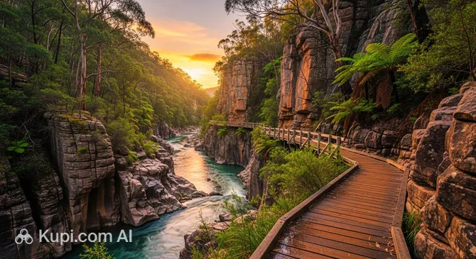
Immerse yourself in the atmosphere of pristine nature by embarking on a journey along one of Victoria's most picturesque routes. The Canyon Walk is a three-kilometer loop trail winding along the banks of the Ovens River in the charming town of Bright. This location harmoniously combines natural beauty with a rich historical heritage dating back to the Australian gold rush.
Canyon Walk. Illustration.
Source: Kupi.com AI
Traveler photos:
The route is famous for its breathtaking views: from crystal-clear river pools to sheer rock formations that create a small but impressive canyon. The path begins as a comfortable sealed walkway, gradually giving way to a more authentic dirt trail that leads travelers through dense thickets of local flora.
The location's popularity is enhanced by two suspension bridges, which allow you to cross the river and enjoy panoramas from different angles. Thanks to its accessibility and beauty, the trail attracts thousands of hikers every year who wish to see the unique blend of the region's industrial past and wild nature.
Contacts
For those planning a walk through the scenic canyon, it is helpful to know the exact coordinates of the trailhead. Although it is a natural site, it has an official address that serves as a convenient reference point near the town center.
The main attraction here is undoubtedly hiking. The route allows you to vary the difficulty of your walk: you can complete the full loop or choose a shorter version by using one of the suspension bridges. Crossing these bridges is an adventure in itself, offering excellent vantage points for observing the rushing current of the Ovens River.
For nature lovers, the trail is an ideal spot for birdwatching and wildlife spotting. The region is particularly vibrant in the spring, when the banks are covered in a carpet of wildflowers, and in the autumn, when deciduous trees paint the canyon in golden and crimson hues. Information stands along the way turn your walk into a fascinating history lesson, detailing the lives of 19th-century gold prospectors.
On hot summer days, many tourists prefer to stop by the river for a swim. However, caution should be exercised: the current can be quite strong, and depths can change suddenly. Experienced travelers recommend bringing water shoes, as the stones on the bottom and near the shore can be slippery and sharp.
Getting There
Finding the start of the route is quite easy: it is located in the heart of Bright, a town nestled in the Australian Alps. The main entrance point is on the southern side of the Star Road bridge, where a sealed path leads travelers west along the river.
If you are arriving by car, it is most convenient to leave your vehicle at the Howitt Park or Centenary Park parking lots, which are in the immediate vicinity of the start and end of the loop trail. The town center is within walking distance, so the trail can be reached from most local hotels in just a few minutes.
For tourists traveling through Victoria by public transport, regional buses connect Bright with major hubs. Within the town itself, you can also use local taxis to quickly get to 8 Star Road from anywhere in the settlement.
Nearest city: Bright
History & Facts
The history of this place is inextricably linked to the gold rush era that swept through Victoria in the early 1850s. The small miners' settlement was originally called Morse's Creek, and it was only in 1861 that it was renamed in honor of the famous British liberal politician John Bright.
Walking the trail today, an observant traveler will notice deep traces left by humans in the landscape more than a century and a half ago. Along the route, old water races have been preserved—channels that gold miners carved directly into the rocks to divert river flows and wash for the precious metal.
Information boards installed at various points along the path reveal not only the technical details of mining but also the complex social history of the region. They tell stories of the daily lives and relationships of miners of different nationalities, turning an ordinary walk into a visit to a living open-air museum.
Time Needed
A standard walk along the full loop trail usually takes about 1 hour. The trail is short, spanning 3 kilometers, making it accessible to tourists of all fitness levels.
However, if your goal is to study the historical artifacts in detail, read all the information boards, and enjoy some nature photography of the rocky shores, you should set aside 1.5 to 2 hours. Additional time may also be needed during the summer months if you decide to stop for a rest by the water.
Working Hours
Access to the trail is open 24/7, allowing tourists to plan their walk at any convenient time. There are no entrance gates or ticket offices, so you can enjoy the silence of the canyon even at dawn.
Nevertheless, to ensure your safety and to be able to see all the details of the historical landscape, it is highly recommended to visit the trail during daylight hours. Since conditions on natural trails can change depending on the weather, it is worth checking the region's official tourism website for any current alerts before heading out.
Open 24 hours
Nearby
The town of Bright is famous for its hospitable atmosphere and many interesting locations situated just steps away from the natural canyon. Exploring the surrounding streets after your walk will help you fully experience the charm of this mountain corner and discover its gastronomic and architectural highlights.