Support

Koningstafel op de Grebbeberg

About

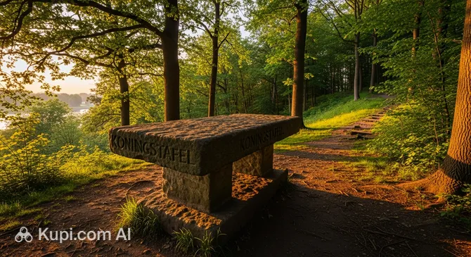
Imagine a place where history meets natural splendor at the very top of a hill. Koningstafel op de Grebbeberg (The King's Table on the Grebbeberg) is a unique viewpoint in the city of Rhenen, offering guests what are perhaps the best panoramic views in the Netherlands. From the 52-meter-high plateau, a breathtaking view opens up of the bends of the Rhine River, dense forests, and the vast expanses of the Utrechtse Heuvelrug National Park.

Koningstafel on the Grebbeberg. Illustration.
Source: Kupi.com AI

Traveler photos:

This site earned its grand name in honor of King Frederick V of the Palatinate, who in the 17th century installed a stone table here for resting during hunting trips. Although the historical artifact has been lost, the "royal" atmosphere and the majesty of the landscape have been preserved to this day. Koningstafel is not just a point on a map, but a living page of history, combining archaeological significance with the quiet beauty of nature.

In addition to its aesthetic appeal, the site is of great interest to history enthusiasts. The hill holds traces of 7th-century fortifications, making a walk here both scenic and educational. It is an ideal spot for those seeking solitude, fresh air, and inspiration amidst picturesque Dutch landscapes.

Contacts

For more information on trail conditions or events in this part of the reserve, you can consult the region's official tourism resources.

How to contactContact
Address3911 AB Rhenen, Нидерланды
Websitewww.opdeheuvelrug.nl

What to Do

The main draw of this place is the opportunity to enjoy the peace and stunning views. The viewpoint looks especially magical at sunset: when the rays of the setting sun paint the waters of the Rhine in golden hues, it creates an ideal setting for meditation or taking spectacular photos. Many travelers bring blankets and picnic baskets to enjoy a cozy lunch in the open air.

For those who prefer active recreation, there are scenic hiking trails laid out around the "King's Table." As you walk along them, you will come across information boards telling the story of the ancient fortifications and the flora of the Grebbeberg hill. This is a great way to combine a light cardio workout with a bit of archaeology. The area is also popular with birdwatchers, as the biodiversity of the national park allows for sightings of rare bird species.

Don't forget to wear comfortable shoes, as the climb up the hill involves walking on natural terrain. A visit to the viewpoint can easily be supplemented with a cycling tour of the surrounding area or an excursion to the nearby historical casemates. It is a wonderful option for a family outing or a quiet weekend trip.

Getting There

The attraction is located in the city of Rhenen at postcode 3911 AB, situated directly on the Grebbeberg height. If you are traveling by car, follow the signs to the hill; there is a parking area at the foot of the hill, from which it is a 10–15 minute walk along scenic paths to the viewpoint.

For those who prefer public transport, the most convenient way is to take a train to Rhenen station (the journey from Utrecht or Arnhem takes about 20–30 minutes). From the station, you can reach the site by local bus, taxi, or rental bike—the distance is about 2–3 kilometers. Cyclists will appreciate the convenience of the Fietsnetwerk routes that pass very close by.

As the viewpoint is located within the Utrechtse Heuvelrug National Park, a visit here is often combined with a full forest walk. During the summer season, parking lots can fill up quickly, so it is worth planning an early arrival.

Nearest city: Rhenen

History & Facts

The history of the Grebbeberg is rooted in the distant past: as early as the 7th century, powerful fortifications stood on this hill. The ring wall with a dry moat, known as Heimenberg, is considered one of the oldest and largest defensive structures in the Netherlands. Scholars believe the fortress was built during the fierce struggle between the Frisians and the Franks in the early Middle Ages.

This location received its current name, the "King's Table" (Koningstafel), in the 17th century. After 1620, the exiled King Frederick V of the Palatinate, also known as the "Winter King," chose this plateau for hunting. According to legend, a massive stone table was installed here, where the monarch hosted lavish feasts while admiring the Rhine Valley. Unfortunately, the table itself has not survived to this day, but the name has remained firmly fixed in the memory of local residents.

The region around Rhenen has historically been an important center of power. Royal estates in this area were mentioned in documents as early as 855, passing between various rulers. Its strategic position above the Nederrijn River made this plateau a key point not only for the nobility's recreation but also for controlling the economy and politics of the central part of the country.

Time Needed

A standard visit to the Koningstafel usually takes between 1 and 2 hours. This is plenty of time to take a leisurely walk to the summit, enjoy the panoramas, read the historical information boards, and take some photos.

If you plan to have an outdoor picnic or wish to explore the more extensive Grebbeberg hiking trails, it is worth setting aside about 3 hours for your visit. The location invites long periods of contemplation, so nature lovers certainly won't find themselves bored here.

Working Hours

As Koningstafel is part of an open natural area, the site is accessible 24 hours a day. You can visit at any time that suits you—whether it's at early dawn or late in the evening.

The attraction is open every day, including weekends and holidays. However, to get the most up-to-date information on any temporary restrictions (for example, during bird nesting season in the reserve), it is recommended to occasionally check the official national park website.

Open 24 hours

Nearby

Exploring the surroundings of the Grebbeberg can significantly enrich your trip. Near the "King's Table," you will find both ancient archaeological sites and military history monuments from various eras.

NameDistance
Ouwehands Zoo0.9 km
Blauwe Kamer Nature Reserve1.3 km
Brasserie De IJsboetiek2.7 km
Restaurant ’t Ambtshuis2.7 km
Cunerakerk2.7 km
't Kalkoentje5.2 km
Het Wapen van Lienden5.7 km

Reached the end of the page?

That means the route is fully explored