Support

Caloosahatchee Creeks Preserve (East)

About

Imagine a corner of pristine nature where dense tropical forests meet swampy river floodplains. The Caloosahatchee Creeks Preserve (East) is exactly such a place, sprawling across more than 530 hectares in the northern part of Fort Myers. This nature reserve in the USA is an essential part of the Caloosahatchee River coastal ecosystem and offers guests a unique opportunity to see Florida as it was hundreds of years ago.

\n\n
Caloosahatchee Creeks Preserve (East)
Caloosahatchee Creeks Preserve (East). Иллюстрация. Источник: Kupi.com AI
\n\n

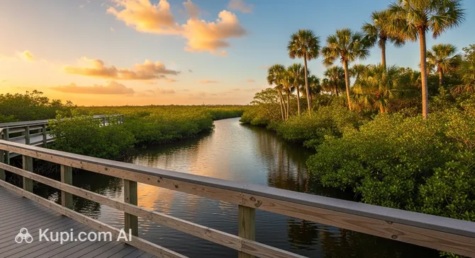
The eastern part of the preserve is particularly attractive for hiking enthusiasts. There are about 7 kilometers of trails here, including picturesque boardwalks and paved paths that wind through fern thickets, oak hammocks, and pine flatwoods. One of the main highlights of this place is its biodiversity: here you can find wild coffee, strangler figs, and majestic palms, creating the atmosphere of a true rainforest.

\n\n

The preserve is highly valued by tourists for its opportunities for secluded relaxation and its high-quality infrastructure. With a 4.6 rating on popular travel platforms, it is considered one of the region's hidden gems. Visitors note the stunning views of the river and marshes, as well as the accessibility of the routes, which are suitable for both experienced hikers and families walking with children.

Contacts

To check current information regarding trail conditions or group events, you can contact the park administration directly. Below are the main contact details for the preserve.

\n\n
How to contactContact
Address10130 Bayshore Rd, North Fort Myers, FL 33917, США
Phone+1 239-707-0862
Websitewww.leegov.com

What to Do

The main activity in this part of the preserve is undoubtedly hiking. You can choose a comfortable path along paved walkways and boardwalks or go looking for adventure on primitive trails through marshes and pine forests. Be sure to check out the Live Oak Trail and Sweet Bay Trail—these routes are famous for their views and allow for a close-up look at local flora, including exotic ferns and wild coffee.

\n\n

For wildlife lovers, the preserve is a true find. You can spend hours birdwatching, spotting green anoles in the thick grass, and, if you're lucky, catching a glimpse of alligators in the marshy zones. A walk along the tidal flooded river trail offers an immersive experience in a tidal river environment, where the landscape changes depending on the water level. It is the perfect spot for those seeking peace and looking to take atmospheric wildlife photos without the tourist crowds.

\n\n

If you plan to spend several hours here, make use of the well-equipped picnic areas. There are sheltered tables near the parking lot where you can enjoy a snack in the fresh air after an active walk. For cyclists, there is designated parking at the entrance, as some of the routes are accessible for two-wheeled transport, making the preserve an excellent destination for active ecotourism.

Getting There

The preserve is located at 10130 Bayshore Rd in the northern part of the city, just east of the busy Interstate 75. If you are coming from downtown Fort Myers, the drive will take approximately 20–30 minutes. You should head north, cross the river, and follow the signs toward Bayshore Road (SR 78). The entrance to the eastern part of the preserve is well-marked, and there is free parking available for visitors right at the trailhead.

\n\n

For those who prefer taxis or services like Uber, the trip is very convenient as drivers can easily find the location by the name of the site or the address. It is worth noting that public transport in this area is limited; there are no direct bus routes to the preserve gates, so a car remains the most reliable way to get there.

\n\n

The road to the preserve is fully paved, making it accessible for all types of passenger vehicles. Once you arrive, you will find information kiosks and restrooms right by the parking lot, allowing you to prepare for your walk before hitting the trails.

Ближайший город: Fort Myers

History & Facts

The history of these lands dates back to the distant past when the territory of the modern preserve was presumably inhabited by the Calusa Indians. Although no direct archaeological evidence of their settlements has been found here, scientists believe they may be hidden under layers of soil left behind after large-scale dredging of the Caloosahatchee River, which began as far back as 1887.

\n\n

In the mid-20th century, this land was used for agricultural purposes. From the 1950s, the area housed citrus groves and cattle pastures. Even today, in some parts of the park, you can find the remains of old irrigation pipes—silent witnesses to the region's farming past. Human impact was significant: in the 1960s, drainage work and soil disposal gradually turned the salt marshes into freshwater tidal wetlands.

\n\n

A new chapter in the site's history began in 2005 when Lee County purchased these lands to create a protected natural area. A large-scale ecosystem restoration plan was launched, including the removal of invasive plants that had taken over nearly 500 acres of the territory. In 2009, a project to restore natural hydrology was implemented in cooperation with US federal services, reconnecting the river with local creeks.

\n\n

Today, Caloosahatchee Creeks Preserve serves as a living example of how nature can recover after decades of exploitation. Thanks to grants from the Florida Communities Trust, modern boardwalks and trails have been built, allowing tourists to explore unique Florida landscapes with minimal interference in the lives of the local wildlife.

Time Needed

To leisurely enjoy the atmosphere of the preserve and walk the main routes, a typical visitor will need between 2 and 4 hours. This is plenty of time to cover the 1.5-mile boardwalk loop and explore the wilder, more primitive trails, which have a total length of about 7 kilometers.

\n\n

If your goal is more than just a walk—such as birdwatching or professional nature photography—it is worth setting aside a bit more time. Many tourists also prefer to combine their hike with a break in the picnic area, which can turn the visit into a full half-day adventure.

Working Hours

The preserve is open daily and welcomes visitors on a dawn to dusk basis. This is typically between 07:00 and 19:00, though exact hours may vary slightly depending on the season and daylight hours.

\n\n

Since the official schedule may be adjusted due to weather conditions or maintenance work, it is recommended to check the official Lee County website or verify current information on Google Maps before your trip.

07:00–19:00

Nearby

After a walk along the shaded trails of the preserve, you can continue exploring the surrounding area. The North Fort Myers district offers both active water activities and educational tours that will perfectly complement your day.

\n\n
NameDistance
Manatee Park2.5 km
Fleamasters Fleamarket8.4 km
Buckingham Community Park9.6 km
IMAG History & Science Center10.4 km
Sidney & Berne Davis Art Center10.6 km
Lovegrove Studios10.8 km
Calusa Nature Center & Planetarium10.8 km

Reached the end of the page?

That means the route is fully explored