Support

Bath Skyline

About

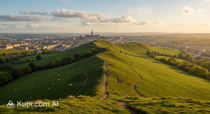
The Bath Skyline is a unique circular walking route that encircles the famous city of Bath, located in the wonderful United Kingdom. This picturesque path, stretching approximately 9.6 km, runs along hilltops offering what are perhaps the most spectacular panoramic views of the historic quarters, the winding River Avon, and endless green valleys.

Bath Skyline
Bath Skyline. Иллюстрация. Источник: Kupi.com AI

The route is a harmonious blend of wild nature and man-made landscapes. The trail leads travelers through shaded woodlands, blooming meadows, and quiet village lanes. One of the most popular spots along the way is Bathwick Hill, where the city's architecture is laid out before you, providing perfect conditions for landscape photography.

The walk begins and ends near Bath city center, making it accessible for tourists wishing to swap bustling streets for the tranquility of the English countryside. This location is ideal for those seeking inspiration in the classic landscapes of Somerset and wanting to see the famous city from an unusual perspective.

Contacts

To check trail conditions or for information on organized events, you can contact the National Trust, which manages the area.

How to contactContact
AddressBathwick Hill, Bath BA2 6EN, UK
Phone+44 1225 833977
Websitewww.nationaltrust.org.uk

What to Do

The main activity here is, of course, hiking. Travelers can test themselves on trails of varying difficulty, alternating between gentle sections in the forest shade and fairly steep climbs. It is a great opportunity to spend time actively and appreciate the diversity of the local ecosystem, from neat fields to dense thickets.

For nature enthusiasts, the Bath Skyline is a true find. Here, you can observe wild birds and small animals in their natural habitat. Families with children often turn the hike into an exciting quest to find animal tracks, while well-maintained open spaces allow for relaxing on the grass among wildflowers.

Photographers and aesthetic lovers will find an endless number of subjects here. The breath-taking views of Bath’s Georgian terraces are particularly beautiful in the pre-sunset hours when the light softly hits the golden limestone buildings. Don't forget to bring binoculars to admire the details of the city's architecture from a bird's-eye view.

Getting There

The journey along the route is most conveniently started right from Bath Spa railway station. This makes the walk accessible for those arriving in the city by train from London or other regions. From the station, the path leads toward Bathwick Hill, where the gradual climb begins.

If you prefer to use public transport, regular buses run from the city center to the start of the trail. You can also use taxi services; the ride to the trail entrance will take only a few minutes.

For motorists, the best option is to leave your car in one of the city center car parks and walk to the start. It is worth noting that the roads directly near the hills can be narrow and parking there is limited, so walking from the center is a more convenient solution.

Ближайший город: Bath

History & Facts

Although the walking route in its modern form was established relatively recently, the land it passes through is inextricably linked to the region's centuries-old history. Bath was recognized as a UNESCO World Heritage site back in 1987, and the surrounding hills played a key role in shaping the appearance of this famous resort.

In the 18th and 19th centuries, when the city flourished as a cultural and health center, landscape parks and gardens on the hills were created specifically for high-society strolls. These areas were designed to highlight the beauty of Georgian architecture, offering the best vantage points of the urban ensembles below.

While walking the Bath Skyline, you can encounter the remains of historic estates and elements of landscape design from past centuries. This place serves as a reminder of the times when outdoor walks were considered an essential part of social life and "taking the waters," turning the surrounding nature into an exquisite backdrop for aristocratic social interaction.

Time Needed

To leisurely complete the entire circular route and fully enjoy the panoramas, it is recommended to set aside about 3-4 hours. This time is quite sufficient to cover the 9.6 km distance, take plenty of beautiful photos, and have a small picnic on one of the picturesque lawns.

Although the route is considered moderate, the presence of steep climbs requires a certain amount of stamina. If you plan to explore the trail with children or want to stop frequently to study the local flora and fauna, it is better to allow half a day for the walk to avoid rushing.

Working Hours

The attraction is open for visits 24/7, any day of the week. This gives tourists complete freedom: you can head out for a walk early in the morning to catch the sunrise over the city or enjoy the evening twilight.

Despite the lack of an official closing time, it is recommended to plan your route during daylight hours, as the trails pass through rugged terrain and woodlands that do not have artificial lighting.

Круглосуточно

Nearby

Exploring the surroundings of the Bath Skyline allows for a deeper immersion into the atmosphere of the English countryside and its hidden treasures. Beyond the main walking loop, you will find both elegant architectural forms and mysterious historical monuments.

Many of these sites are within a short drive or a pleasant walk, complementing your visit to Bath with new discoveries—from ancient castles to picturesque estate gardens.

NameDistance
Sotto Sotto1.1 km
Bath Lookout1.2 km
Edesia1.3 km
Alexandra Park1.3 km
Theatre Royal, Bath1.5 km
Fashion Museum Bath1.7 km
The Scallop Shell1.7 km

Reached the end of the page?

That means the route is fully explored