Support

Rishiri Rebun Sarobetsu National Park

About

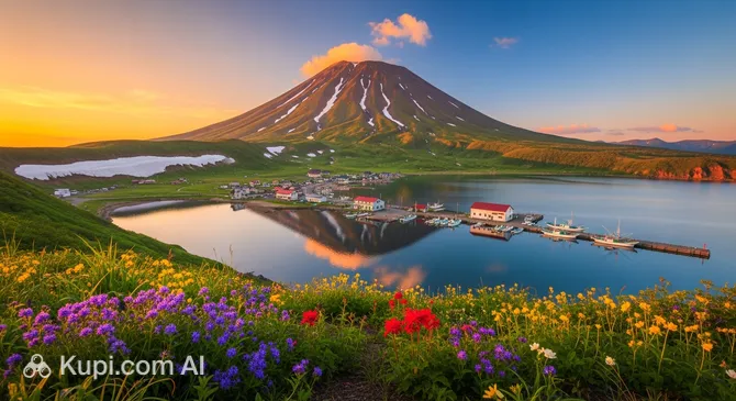
Imagine the rugged yet delicate beauty of the northern edge, where volcanic peaks rise above the cold ocean waters. Rishiri-Rebun-Sarobetsu National Park is a unique natural complex in Hokkaido Prefecture, located in the town of Rishiri. This territory in Japan combines snow-capped peaks, alpine meadows, and vast coastal wetlands.

Rishiri-Rebun-Sarobetsu National Park
Rishiri-Rebun-Sarobetsu National Park. Иллюстрация. Источник: Kupi.com AI

The park's main landmark is the majestic Mount Rishiri (1,721 m), a dormant volcano often called "Northern Fuji" due to its graceful silhouette. The park covers approximately 21,200 hectares and includes not only mountain ranges but also the famous "flower kingdom" of Rebun Island, as well as the Sarobetsu marshy plains, which are vital for migratory birds.

This destination attracts eco-tourism enthusiasts with its pristine state. Here, you can encounter rare plant species that grow nowhere else in the world and enjoy a silence broken only by the sound of the wind and the cries of seabirds. The park is a complex mosaic of ecosystems, from tundra to lagoons, making it one of the country's most valuable reserves.

Contacts

To plan your visit to this remote natural gem, it is helpful to have the current contact details for the administration and visitor centers on hand.

How to contactContact
AddressКуцугата, Рисири, Rishiri District, префектура Хоккайдо 097-0401, Япония
Phone+81 11-299-1950
Websitewww.env.go.jp

What to Do

Outdoor enthusiasts will find routes here for every taste—from leisurely strolls to serious challenges. The main challenge for hikers is the Rishiri Ridge Trail. The climb to the volcano's summit takes several hours, but the reward is breathtaking panoramic views of the Sea of Japan and neighboring islands from a bird's-eye view.

On Rebun Island, it is worth heading out on a photography adventure through the alpine meadows. During the summer season, thousands of rare flowers bloom here, including edelweiss and endemic orchids, turning the hills into a vibrant living carpet. For those who prefer the water, kayak trips along the rivers of the Sarobetsu plateau or sea excursions to spot marine mammals are available.

After a busy day, there is nothing better than relaxing in one of the local onsens—hot mineral springs located right at the foot of Mount Rishiri. In winter, the park transforms, offering thrill-seekers opportunities for ski touring and snowboarding on wild volcanic slopes covered in deep, powdery snow.

Getting There

The journey to this protected corner of Japan usually begins with a flight to Rishiri Airport (RIS) from Sapporo or Niigata. Upon arrival, you can use local buses or taxis to reach the settlement of Kutsugata, which serves as the starting point for many routes.

Another scenic route is the ferry service from the city of Wakkanai on Hokkaido. Ferries run regularly: the trip to Rishiri Island takes about an hour, and to Rebun Island, it takes about an hour and a half to two hours. In the summer months, when tourist traffic increases, it is recommended to book ferry tickets in advance through the carriers' official services.

To visit the mainland part of the park, the Sarobetsu Plain, it is most convenient to take a train or bus from Wakkanai (the trip takes about an hour). For travelers who prefer complete freedom of movement, renting a car in Hokkaido is recommended, allowing you to easily reach the most remote viewpoints using GPS coordinates.

Ближайший город: Rishiri

History & Facts

The park's official history began on July 1, 2005, when it became the country's 28th national park. This decision brought the unique ecosystems of Rishiri and Rebun Islands, as well as the Sarobetsu wetland plain, which were previously protected as separate natural monuments, under a single umbrella. The primary goal of establishing the park was to preserve the fragile subarctic flora and rare alpine plants.

Historically, these lands were the home of the Ainu, the indigenous people of the north. In their culture, Mount Rishiri held a sacred place and appeared in legends as the "Maiden Mountain." The Ainu lived in harmony with the local nature, engaging in fishing and hunting, and their heritage is still traceable today in place names and local folklore.

From the late 19th century, during the Meiji period, the islands began to be actively developed by Japanese settlers. The development of fishing and logging brought economic prosperity but also posed a threat to the wilderness. The recognition of the value of these landscapes in the 20th century led to strict protection measures, and as a result, the park is now part of the global UNESCO network for biodiversity conservation.

Time Needed

To fully appreciate the diversity of the landscapes, travelers are recommended to set aside 3 to 5 days for visiting the park. This time is enough to dedicate a day or two to climbing Mount Rishiri, explore the flower trails of Rebun, and spend several hours on the Sarobetsu Plain.

If you only have one day at your disposal, it is better to focus on a single area—for example, choosing a walking route around a lake at the foot of the mountain. However, keep in mind that logistics between the islands depend heavily on ferry schedules, so careful planning of your time is critical here.

Working Hours

A huge advantage of the park is its accessibility: the main natural areas and hiking trails are open for visiting 24 hours a day. You can plan your ascent to catch the sunrise at the summit or enjoy the sunset on the coast at any convenient time, as there are no restrictions on entry hours.

However, it is worth remembering that information centers and equipment rental points have their own internal schedules. For the latest data on trail conditions and weather, it is recommended to check the official website or visit the visitor center in Kutsugata before heading out on your route.

Круглосуточно

Nearby

Exploring the surroundings of the national park allows for a deeper immersion into the atmosphere of the northern islands and provides a chance to see Hokkaido's natural beauty from new perspectives. The proximity of the sea and volcanic slopes creates many opportunities for short radial trips.

Name Distance (km)
Chokan yama 1.8
Rishiri Island 3

Reached the end of the page?

That means the route is fully explored