Support

Jacks Peak Park

About

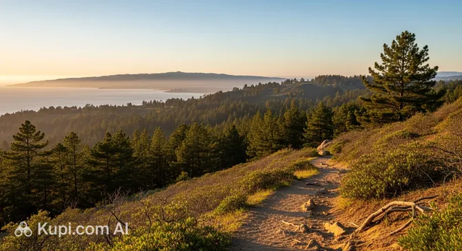
Rising above the misty California coast, Jacks Peak Park is the true natural crown of the peninsula. This protected area in the USA, spanning over 212 hectares, is the highest point in the region, offering travelers breathtaking panoramas of the bay and the picturesque Carmel Valley. Situated at the intersection of wilderness and the urban boundary of Monterey, the park serves as a sanctuary for rare flora and fauna.

Jacks Peak Park
Jacks Peak Park. Иллюстрация. Источник: Kupi.com AI

One of the park's primary features is its unique forest, home to one of only three remaining natural stands of Monterey pines in the world. Walking under the canopy of these majestic trees feels like entering a natural "cathedral," where the air is thick with the scent of pine needles and sea breeze. Beyond botanical rarities, the park surprises geology buffs: Miocene-era fossils are still found in the local shale rocks, testifying to the ancient marine past of these hills.

This destination is perfect for those seeking solitude away from the noisy tourist waterfronts. At an elevation of 325 meters above sea level, Jacks Peak provides the best angles for landscape photography and birdwatching, making the park a must-visit for eco-tourism enthusiasts and those who enjoy quiet walks in the fresh air.

Contacts

To plan your visit to this natural gem, it is helpful to have basic information about its location and official resources. Since the park is managed by county authorities, up-to-date information on trail conditions can always be found on their portal.

How to contactContact
Address25020 Jacks Peak Park Rd, Monterey, CA 93940, США
Websitewww.co.monterey.ca.us

What to Do

The main draw for visitors is an extensive network of hiking trails totaling over 13 kilometers. If you are short on time, be sure to head to the Skyline Self-Guided Nature Trail. This trail follows the very crest of the peak and features informational signs about local plants, animals, and ancient fossils that can be spotted right under your feet.

For those who prefer a more relaxed experience, the park is equipped with cozy picnic areas. It is important to remember that for safety reasons, only propane grills are allowed—open fires using wood or charcoal are strictly prohibited. It is a fantastic spot for a family lunch in the open air with views of Monterey Bay.

Ornithologists and photographers will appreciate the park as part of the "Central Coastal Birding Trail." Armed with binoculars, you can encounter numerous bird species here, as well as deer and foxes that often come out near the trails during morning and evening hours. In summer, the hillsides transform into a vibrant carpet of wildflowers like Indian paintbrush and California sagebrush, creating perfect conditions for macro photography of the flora.

Getting There

The easiest way to reach this scenic spot is by car. The main route follows State Highway 68 (HWY 68). If you are driving from downtown Monterey, the trip takes only 10–15 minutes: simply turn onto Jacks Peak Park Rd and follow it to the entrance. Parking is provided on-site, though there is an entrance fee (typically around $10 per vehicle).

For those who prefer public transportation, the journey is a bit more challenging. You can take MST bus lines 4 or 5 to a stop on HWY 68, but from there, you will need to hike about 2–3 kilometers uphill or call a taxi. From Monterey Regional Airport, the drive takes approximately 20–25 minutes.

Cyclists should note that while you can ride to the park gates, bicycles are strictly prohibited on the trails within the conservation area. Walking from the city is possible but requires good physical fitness, as the 5–7 kilometer route is a steady uphill climb.

Ближайший город: Monterey

History & Facts

Long before the first European explorers arrived on these hills, the territory of the modern park was inhabited by the Rumsen Ohlone tribe. The indigenous people lived in harmony with the local ecosystem, using the rich natural resources for food and shelter. In the late 18th century, with the arrival of the Spanish, these lands became part of colonial grants and later part of the Mexican Rancho Aguajito.

The park gets its modern name from David Jack, a Scottish immigrant who purchased significant parcels of land at auction in 1859. Interestingly, the name "Jacks Peak" traditionally does not use an apostrophe. For a long time, the land was used by the Jack family for farming and cattle grazing, which helped protect the area from dense urban development.

The journey toward turning this private land into a public asset began in 1964, when philanthropists Talcott and Margaret Pardy Bates purchased the first 55 acres to save them from developers. The land was later transferred to the Nature Conservancy and eventually to Monterey County. Thanks to the efforts of local activists and officials, Jacks Peak Park officially opened to the public in January 1977.

Today, the park is not only a recreation area but also an important scientific site. Unique Miocene-era fossils can be found hidden in the shale rocks. This serves as a reminder of the times when these mountain peaks were deep underwater, highlighting the remarkable geological history of the California coast in the USA.

Time Needed

To leisurely walk the main trails and enjoy the views, most visitors need between 2 to 4 hours. This is plenty of time to hike the popular Skyline Trail, reach the highest point, and enjoy a small snack at one of the picnic areas.

If you plan to explore every corner of the park, including the remote equestrian trails and a detailed study of the geological fossils, it is worth setting aside half a day (about 4–6 hours). The park's quiet atmosphere encourages long contemplation, so many tourists prefer not to rush, lingering at lookout points with binoculars or a camera.

Working Hours

Jacks Peak Park welcomes guests daily, opening its gates at 08:00 and closing at 19:00. This schedule is consistent throughout the week, including Saturday and Sunday.

As daylight hours change, the administration may make seasonal adjustments to the schedule. Before your trip, it is recommended to check the official Monterey County website to confirm current operating hours and ensure there are no temporary trail closures due to weather conditions.

08:00–19:00

Nearby

A visit to the park can easily be combined with exploring other iconic spots on the peninsula. Thanks to its proximity to the historic center and the coast, you can transition from the quiet of a pine forest to the bustle of the oceanfront or the architectural grandeur of historic buildings in a single day.

NameDistance
San Carlos Cathedral3.8 km
Dennis The Menace Playground3.9 km
Monterey County Youth Museum4.2 km
Brophy's Tavern4.3 km
Mission Bistro4.3 km
Carmel Plaza4.3 km
Tap Depot4.4 km

Reached the end of the page?

That means the route is fully explored