Support

Westminster Ponds/Pond Mills Conservation Area

About

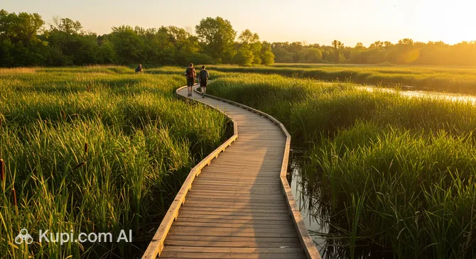
Westminster Ponds Conservation Area is the largest environmentally significant natural area in the city of London, located in the country of Canada. Covering an area of about 200 hectares, this site is a unique example of wildlife preservation within city limits. The conservation area includes five majestic kettle ponds surrounded by dense forests, meadows, and wetlands.

Westminster Ponds Conservation Area. Source: Kupi.com AI

This location holds the status of a provincially significant wetland due to its striking biodiversity. It is home to about 60% of all plant species in Middlesex County, including rare tamarack and leatherleaf communities. A walk through the area reveals changing landscapes: from shady maple forests to the open waters of Beaver Pond.

Westminster Ponds is especially valuable for ecotourism enthusiasts. The combination of accessibility and untouched nature makes it a popular destination for both family outings and serious scientific observations of the region's flora and fauna.

Contacts

When planning a visit to the Westminster Ponds Conservation Area, it is helpful to have official contact information at hand. You can check for updates on trail conditions or events by phone or on the organization's website.

Address 696 Wellington Rd, London, ON N6C 4R2, Canada
Phone +1 519-451-2800
Website thamesriver.on.ca
Google Maps Open Map

What to Do

The main activity in the conservation area is hiking along 11 kilometers of managed trails. The routes are carefully marked with yellow markers, and wooden boardwalks are installed in the wettest lowlands, making exploration comfortable even after rain. The terrain is mostly gentle, though there are some short steep climbs that add a dynamic feel to the walk.

For wildlife lovers, this is an ideal spot for birdwatching. The conservation area serves as an important stop for migratory species: you can see songbirds, herons, ducks, and even majestic Great Horned Owls. Additionally, fishing is permitted on the territory (with a provincial license), attracting those who enjoy quiet relaxation by the water.

Visitors are encouraged to stay on the marked paths to avoid disturbing the fragile ecosystems. Picturesque views of the ponds and centuries-old trees offer stunning opportunities for landscape photography throughout the year, especially during the forest's autumn transformation.

Getting There

The conservation area is conveniently located in the southern part of the city at 696 Wellington Rd. The main entry points are south of Commissioners Road and east of Wellington Road, right next to the local Tourist Information Centre. Getting here by car is straightforward, and parking spaces are provided near the entrances.

For those who prefer public transport, city buses run regularly to this area. You can also use a taxi or ride-sharing service from downtown London; the trip takes about 10–15 minutes. It is recommended to use the official access points marked on maps to immediately reach the information stands with trail maps.

History & Facts

The history of this amazing place began about 13,000 years ago. The kettle ponds of the area were formed during the retreat of the glaciers: huge blocks of ice left deep depressions in the ground, which eventually filled with water. Today, these water bodies are a living monument to the Ice Age.

The lands around the ponds have been home to Indigenous peoples since ancient times, including the Attawandaron, Anishinaabeg, and Haudenosaunee nations. Archaeologists have discovered traces of campsites here estimated to be 4,500 years old, highlighting the long-standing connection between people and this unique ecosystem.

The more modern history of the region is linked to European settlers who began developing the area around the city of London in 1810. An interesting historical artifact is the railway line laid through the territory of the current conservation area in 1915. It connected the city with Port Stanley and played an important role in local logistics in the early 20th century.

Time Needed

To take a leisurely stroll through the main routes and enjoy the lake views, an average visitor will need between 2 to 4 hours. This is the optimal amount of time to walk a couple of trails, take photos, and observe the local fauna by the water's edge.

If you are a professional birdwatcher or plan to hike all 11 kilometers of trails, you should set aside half a day for your visit. The peaceful atmosphere of the area encourages a long stay in the fresh air, away from the city noise.

Working Hours

Westminster Ponds Conservation Area welcomes visitors at any time: it is open 24 hours a day, seven days a week. This provides an excellent opportunity to see nature in different light—from misty dawns to quiet twilights.

Since there is no lighting on the forest trails at night, it is recommended to plan your walks during daylight hours for your safety and for the best view of the natural attractions.

Nearby

Exploring the natural riches of Westminster Ponds can be complemented by visiting other interesting locations in the city. Within a radius of a few kilometers, you can find both modern entertainment centers and historical landmarks that will help you learn more about the region's culture and heritage.

Name Distance (km)
Splash Park 4.4
Middlesex County Court House 4.4
St. Peter's Cathedral Basilica London, ON 4.8
Victoria Park Gateway 4.9
CPKC London Train Station 5.5
East Park London 5.6
The Royal Canadian Regiment Museum 5.9
Storybook Gardens 7.4

Reached the end of the page?

That means the route is fully explored