Support

Jacob-Bellecombette Cascade

About

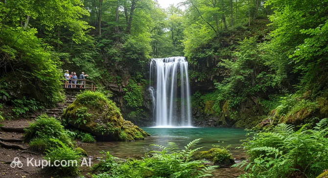
Hidden in the lazy shade of dense forests, the Jacob-Bellecombette Waterfall (or Jacob Cascades) is an enchanting group of three natural waterfalls. This natural wonder is located in the commune of Jacob-Bellecombette, just a few steps from the city of Chambéry. The heart of the cascade is the crystal-clear Nant du Pontet stream, which originates high in the mountains.

Jacob-Bellecombette Waterfall
Jacob-Bellecombette Waterfall. Иллюстрация. Источник: Kupi.com AI

This spot is rightfully considered one of the most peaceful and photogenic corners that France has to offer in this region. Surrounded by mossy rocks and wild vegetation, the waterfalls create an atmosphere of a pristine Alpine forest. From the upper points of the trail, breathtaking panoramas open up to the surrounding hills and the famous Lake Bourget in the distance.

The Jacob-Bellecombette Cascades are not just a flow of water, but an entire ecosystem where the sound of the water blends with birdsong. For tourists, it is the perfect opportunity to escape the city bustle and touch the natural beauty of Savoy without traveling far from civilization.

Contacts

If you have any questions regarding the condition of the hiking trails or local events, you can refer to the official resources of the commune.

How to contactContact
AddressRte de la Cascade, 73000 Jacob-Bellecombette, Франция
Phone+33 4 79 69 08 37
Websitewww.jacob-bellecombette.fr

What to Do

The main draw for visitors here is the well-maintained “Sentier des Cascades” trail. Walking along this route, you can cross small bridges over the stream and reach the base of the first waterfall. For those who enjoy physical activity, there are steep steps leading to the upper cascades, which offer the best views of the falling water.

Information plaques along the path tell the story of the local industry and the history of cement production, turning a simple walk into a small historical exploration. Panorama lovers should definitely make it to the viewpoints, from which Lake Bourget and the mountain ranges are clearly visible on a clear day.

The location is ideal for photoshoots: the mossy stones, the play of light in the water jets, and the woodland scenery look magnificent at any time of year. Many tourists bring picnic baskets to enjoy a snack in the shade of the trees by the stream while listening to the sound of the water. The route also passes by the old Gaec Tochon farm and the hamlet of La Grobelle, offering a glimpse into the traditional lifestyle of the French province.

Getting There

Getting to this natural spot from the city center is quite easy. If you prefer walking, the trip from the center of Chambéry takes about 40–45 minutes. The main entry point for the route is the parking lot near the Grand Pré school in the commune of Jacob-Bellecombette. From there, head down Rue des Écoles and follow the "Sentier des Cascades" signs along the picturesque stream.

For those traveling by car, follow Route de la Cascade or the departmental road D912. Navigation coordinates: 45.553755, 5.9106734. There is usually plenty of space near the start of the trail to leave your car and begin your ascent.

Public transport is also an option. Regular city buses connect the central districts with stops in Jacob-Bellecombette. After getting off the bus, the walk to the start of the trail takes no more than 10–15 minutes. Alternatively, you can call a taxi, which will take you directly to the start of the hiking route in just a few minutes.

Ближайший город: Chambéry

History & Facts

This area is steeped in romantic 17th-century legends. It is said that the waterfalls were a favorite spot for resting and bathing for Hortense Mancini, the niece of the famous Cardinal Mazarin and Duchess of Mazarin, who sought solitude and the cool of the Alpine waters here.

Beyond its aesthetic value, the Le Pontet stream played a vital role in the region's industrial development. Information boards along the trail tell the story of the "cement adventure." This was once the site of quarries and cement production plants. Until 1912, stone was transported by oxen; later, a narrow-gauge railway was built, and in the 1920s, there were even gondola lifts for transporting raw materials.

The Savoy region has always been famous for its industrial past, harmoniously integrated into the landscape. Today, a walk through the area allows you to see not only the beauty of nature but also the traces of this rich history, making the route educational for tourists of all ages.

Time Needed

To enjoy all the cascades and views at a leisurely pace, it is recommended to set aside 2–3 hours. This is plenty of time to walk the "Sentier des Cascades" loop trail, take memorable photos at the base of the waterfalls, and relax on the specially provided benches.

If you are short on time, you can take an express walk just to the first and most accessible waterfall. In this case, the round trip will take only 30–40 minutes. However, keep in mind that the climbs to the upper points may require a bit more effort and time for rest.

Working Hours

As a natural site, the cascades are accessible daily and around the clock. There are no gates or ticket offices, so you can plan your walk for early morning to catch the sunrise in the forest or for the pre-sunset hours.

Nevertheless, it is recommended to visit the waterfalls during daylight hours for safety on the forest trails. Before your trip, it is advisable to check the official commune website to ensure that the routes are not closed for maintenance or due to weather conditions.

Круглосуточно

Nearby

Exploring the surroundings of the waterfalls will allow you to dive deeper into the atmosphere of Savoy. Very close to the natural area are historical monuments, castles, and cultural venues that will perfectly complement your walk.

NameDistance
Le Win's Field0.8 km
Château of the Dukes of Savoy1.4 km
Petit Hôtel Confidentiel Bar1.4 km
Le 22 Chambéry1.5 km
Les Charmettes – Jean-Jacques Rousseau's House1.5 km
Savoisien Museum1.6 km
Eureka Gallery1.6 km

Reached the end of the page?

That means the route is fully explored